Author
Bijaya K. SHRESTHA
Ph.D. MUD. B. Arch. Urban designer, Nest Pvt. Ltd., Lalitpur, Nepal
Email: bkshrestha2014@gmail.com
Abstract
This paper studies the unique features of private houses in the satellite ‘Newar’ town of Bungamati, planned by bringing 100 people from Kathmandu, Lalitpur, and Bhaktapur. Building facades of all four sides of Machchendra bahal in 1968, before the 2015 earthquake and in 2024, were analysed considering both qualitative and quantitative elements. Dominating sloped roofs, plane brick exposed façade with vertically oriented windows and simple cornices, and stone plinth with steps only in front of the door are the architectural characteristics of Bungamati. These elements are not visible in the modern buildings, especially built in the post-earthquake period. To reverse the trend, architectural design guidelines are proposed along with quantitative parameters: a recommended ratio of area of opening (door and window) to façade area between 0.20 and 0.35 and a suggested ratio of sloped roof height to total building height between 0.10 and 0.25.
Key words
Architectural design guidelines, Bungamati, Newar town, Machchendra bahal, Earthquake
Contextual background and study objectives
Located about 10 km south of the capital Kathmandu, Bungamati is an ancient 6th-century ‘Newar’ satellite town located in Laliptur Metropolitan City (LMC). It is believed that 100 people from each principal cities of the Kathmandu valley – Kathmandu, Lalitpur and Bhaktapur – were brought into this area at the time of King Narendradeva and housed them around ‘Machchendranath’ (Bunga-dyah or god of rain) in three different directions with construction of three artificial ponds corresponding to each community. The town comprises numerous Hindu and Buddhist monuments in the form of temples, monasteries, rest houses, sunken stone spouts and so on. This planned ‘Newar’ town was fitted into the local topography and rural context, thereby producing unique architectural character and built form. It adds value to the existing knowledge of historic settlements of the Kathmandu valley. Spread over 3.88 sq. km area, Bungamati (i.e., former Bungamati village development committee, present ward 22 of LMC) had a population of 5,667 in 2001 and 5,966 in 2011 and less than 6,000 in 2021. Major historic settlement of Bungamati is confined in a small area with a population of 3,932 in 2011 and around 4,162 in 2021 (UN-Habitat, 2019). Though agriculture was the main source of income in the past, only 9% of the households at present rely on it for day-to-day earnings (Lumanti Support Group for Shelter, 2019). Major profession involved is carpentry (29%), followed by business (18%) and craftsmen (12%) and wagebased business (10%) (ibid.). The 2015 Gorkha earthquake and its aftershocks destroyed 54% (out of 856 houses) completely, another 6% were damaged beyond livable condition and 29% were partially affected (ibid).
Bungamati among other historic settlements of the Kathmandu valley got top priority on post-earthquake reconstruction. UNHabitat, Nepal along with many agencies under the switch Asia grants program (funded by the European Union) carried out a socio-economic survey, prepared a settlement recovery plan along with (UN-Habitat, 2019) and an inventory of Bungamati heritage (UN-Habitat, 2020), reconstructed ‘Ta Phalcha’ (rest house) of Machchendra bahal and revitalization of ‘Dey pukhu’ (Nations’ Pond), besides training local carpenters on wood carving. The reconstruction of public monuments and rest houses is being performed through government budget and supports from donor agencies. However, the reconstruction of private houses is slow not only due to financial problems and social issues. Those already constructed houses have raised an issue about whether such construction has promoted the conservation of unique architectural character of Bungamati. Against such a backdrop, this paper intends to propose key architectural design guidelines for the construction and renovation of private individual houses in Bungamati with threefold objectives. First, it sets a context of understanding the unique built form of Bungamati. Second, it explores salient features of the architecture of private houses in Bungamati and then checks the transformation of them especially in post-earthquake reconstruction. Third and last, it proposed some key architectural design guidelines for the reconstruction and renovation of individual private houses.
Study site and parameters for formulation of urban and architectural design guidelines
Among many public open spaces in Bungamati, the ‘Machchendra bahal’ is the singular most important courtyard, measuring roughly 55m X 55m. The ‘Hayagriva’ temple occupies the south-eastern space, and a flower garden dedicated to the deity is fenced off within the enclosure. The encircling forty houses of this courtyard were selected for the detailed analysis of architectural character. Among them, 26 buildings were damaged beyond livable conditions during the 2015 earthquake (Figure 1). About 15 houses were already rebuilt and still 11 plots remained vacant. The newly reconstructed houses have followed the prevailing building byelaws, besides being designed by architects and engineers, yet they do not fit in the site in terms of their bulk, building envelope and detailing on front façade.
This study analyses both qualitative as well as quantitative aspects of individual houses to explore architectural character of houses of Bungamati constructed over different time periods (Table 1). On qualitative aspect, three elements of building façade were studied in detail: roof type, façade (door and window opening, cornices, etc.) and transitional spaces between the ground floor and public street (or open space). Transitions in these elements were noticed by analyzing the building facades developed in three different periods; in 1968, before the 2015 earthquake and in 2024.
The important architectural elements identified in the past were vertical plane of the building façade with projection of balcony on the second floor, dominating sloped roof supported by struts, vertically oriented wooden door and window openings, cornices separating different floors and detailing of the ‘transitional space’ between the public and private domain of spaces. Similarly, urban blocks and fabrics, building bulk and envelope, ratio of opening area to the façade area (excluding roof area) on façade, and percentage of sloped roof against the total building height, seen in building elevation were analyzed in detail of houses built in different time periods.
This study combined both qualitative and quantitative data for analysis. Numerous published documents and past photos were collected from various sources. The site was visited many times to draw façade elevation and to check building detailing. The local people and municipal staffs were also consulted.


Fig 1 Machchendra bahal within Bungamati as a study site (Source: Centre for Culture and Development, 1968)
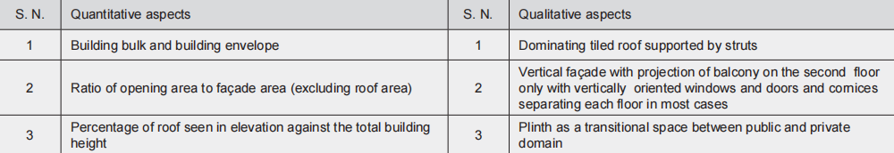
Table 1 Qualitative and quantitative aspects of houses in historic core area
Built form of Bungamati
The built form of Bungamati has adjusted to the local topography and its rural context in many ways. First, the town was located at higher ground, characterised by a compact form with building layout around courtyards and linear spaces (nani) (Figure 2a). Unlike the 'Newar' towns in the urban context, which are 'palace' concentric with segregation of housing for high officials, traders and craftsmen (upper cast Newars) surrounding the centrally located palace complex and the lower caste progressively living further away, housing in Bungamati was positioned across 'Machchendranath' temple as an 'anchoring node' with three communities residing in different directions – ‘Shakya’ families from Kathmandu towards north-east, ‘Shrestha’ communities from Bhaktapur towards east and ‘Maharjan’ households from Lalitpur in the south-east (Figure 2b).
A separate artificial pond was built for each community to carry out socio-religious and ritual works: ‘Dey pukhu’ for Shakya family, ‘Kha pukhu’ for Shrestha community and ‘Na pukhu’ for Maharjan households. The latter two were located in the peripheral areas whereas the former was constructed inside the historic settlement towards the north side, as it has a functional relationship with the main shrine of ‘Machchendranath.’ In addition to these, small size of Khadgi and Mali (Gathu) communities live on the northern part of the settlement. Unlike the completely ‘enclosed courtyards’ with continuous encircling buildings in the city areas, the majority of the housing in Bungamati are composed of individual structures encircling the open spaces with multiple entry access (Figure 2c). Otherwise, buildings generally have a vacant plot backside, used for ‘a vegetable garden’ and utility functions. The tradition of keeping large open spaces (khyo) for public benefit at the peripheral areas in ‘Newar’ settlement was continued here.
The urban fabrics of neighborhood of these communities are different (Figure 3). For instance, Shakya and Tuladhar communities living around Machchendra bahal have a courtyard-type housing layout whereas the Maharjans’ housing is lined up around ‘nanis’ and small courtyards.
Second, the street patterns are of 'irregular shape' and 'size' following the local topography and orientating towards the ‘Machchendranath temple complex.’ Having different hierarchies, streets of different widths (3m-4.5m black top, 2m-3m brick paved and 1.5m -2.5m stone paved) with buildings of 3-4 stories (6.5m-8.5m) lining continuously on both sides have produced a 'street width to building height' ratio of 1:2.0 to 1:3.0. This combined with unifying elements on building façade with little variation in roof line has formed a 'sense of enclosure' and 'human scale.' Visitors feel mystery, surprise, excitement and anticipation due to sequential spatial events and 'singular composition.' Streets and open spaces equipped with temple, well and drinking water tank, coexistence of Hindu and Buddhist shrines (and temples) as well as communities in the same neighbourhood together with celebration of numerous local festivals constitute the socio-cultural setting for the town. They are not only 'paths' for the movement of pedestrians and goods, but they are more like a 'shared community space' for multiple functions. They are the places for three different activities: necessary activity (going to school, work, shopping, etc.), optional activity (sitting and sunbathing, standing around, etc.) and social activities (children playing, cloths and utensil washing, grain drying, conversations, passive contact, etc.), thereby promoting socialization among different age groups and neighbours. Religious structures such as 'dabali' (square platform) and 'pati' (rest house) have been used for display of god and goddess images, performance of religious dance and drama as well as for ‘bhajan and kritan’ (religious pray). It has provided an opportunity for interaction of private and community life to enhance social bonds. This combined with the significant places like ‘chhwasa’ (a place protected by a demon) and ‘lachhi’ (private space in front of the house allocated for public use) adds cultural meaning to the streets and public squares.
Third, community spaces in front of individual houses are part of architecture, and without such spaces, an individual structure cannot function as a house. Numerous daily activities, such as weaving, knitting, bathing and washing, including socialization with neighbors, take place in such 'transitional spaces' between the 'private house' and 'public' street.
The urban block was fine-grained and buildings facing the streets were built first, leaving vacant plots at the back. The infill development took place over time, responding to the needs of the community at that time. This creates a social fabric evolving over time from lightly developed residential areas to mixed-use retail to the dense urban core. Each individual plot has a different owner. It is more walkable as there are more destinations within walking distance.
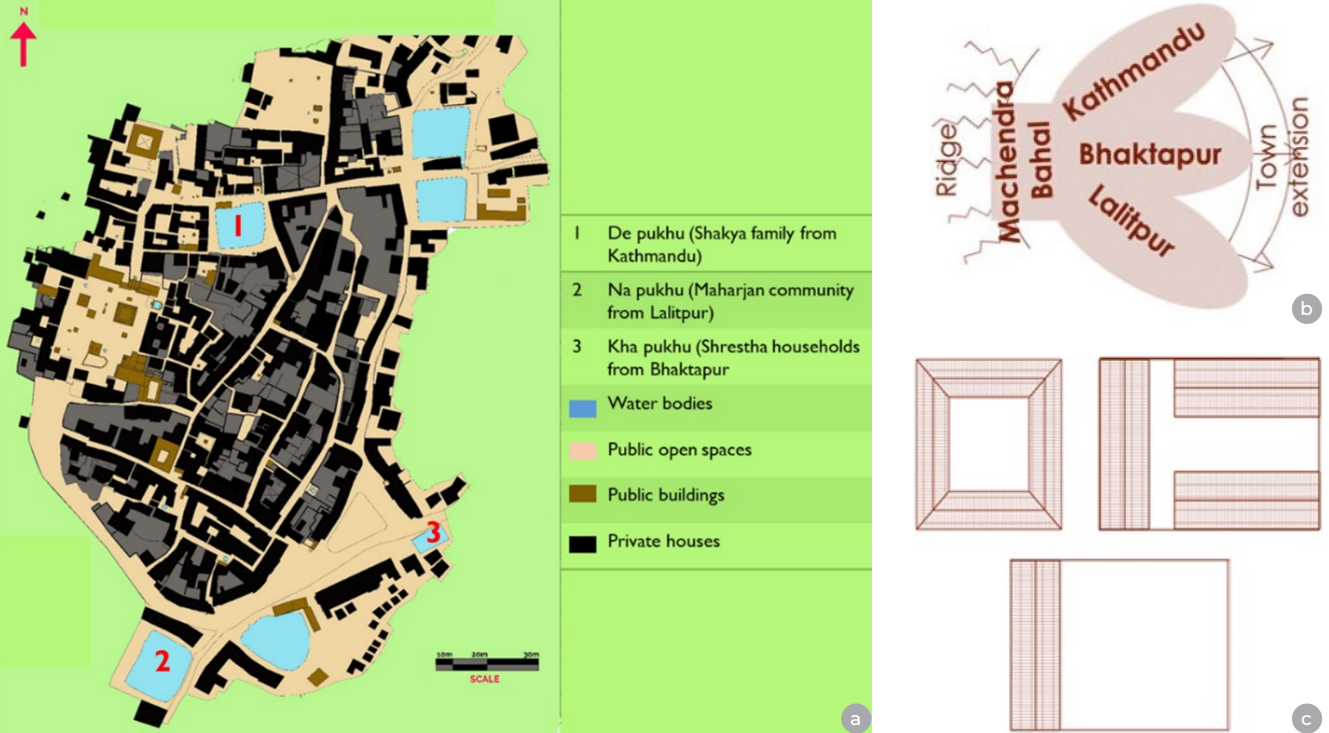
Fig 2 Salient features of built form of Bungamati, (a) Compact settlement around courtyards and lanes (nanis), (b) Housing of three communities anchoring by Machchendra bahal, (c) Typology of building on plot
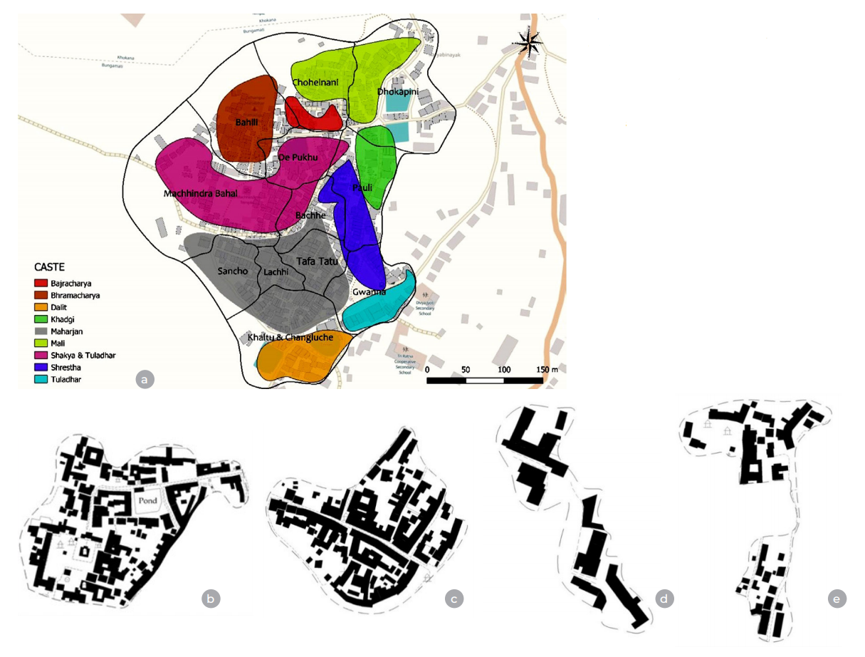
Fig 3 Urban form of neighborhood inhabited by different caste groups in Bungamati, (a) Housing location for various NewariNewar caste, Bungamati (Source: Lumanti support group, 2019), (b) Shakya and Tuladhar, (c) Maharjan, (d) Shrestha, (e) Mali and Khadgi
Quantitative aspects of houses built in Bungamati in different time periods
1. Building bulk and envelope
The traditional houses in Bungamati used to have two-way sloped roofs with a flat façade on both sides (Figure 4a). Some houses have wooden balcony projection on the second floor. Various socio-economic and daily activities used to perform on building frontage and public open spaces. Modern buildings are of reinforced cement concrete (RCC) frame structure with flat roofs and projection of slabs (or balconies on multiple floors) (Figure 4b). In other cases, traditional load-bearing houses are being divided vertically and then renovated or reconstructed the divided part by creating door and window openings on the load-bearing walls, thereby not only destroying the scale and proportion of traditional houses but newly built houses are often different in terms of building bulk and envelope.
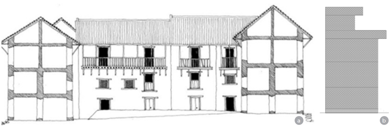
Fig 4 Building bulk and envelope of houses in Bungamati in the past and present, (a)Building envelope dominated by sloped roof in 1968, (b)Building envelope dictated by balcony projection at present
2. Ratio of areas of door and window opening to façade area and ratio of roof height to total building height in houses built in different periods
Elevations of all four sides of houses at Machchendra bahal in three different time periods: in 1968, before the 2015 earthquake and in 2024, are prepared from the photographs taken at the site and secondary sources. There are many public buildings in the form of rest houses, community buildings and ‘dyahchen’, especially on the northern façade. The ‘bahal’ itself houses numerous public monuments in the form of temples, chaityas, wells, gardens, sunken stone spouts (hitis) and so on.
The elevation of houses (facades) in 1968 presents a unifying element in architectural style, scale and proportions, including building materials and construction technology. Though each house is different from others in size and scale, nonetheless, they have unifying elements – brick exposed vertical plane façade, vertically oriented door and window openings, sloped tiled roofs and simple cornices in some houses, separating different floors. Buildings are placed over a raised stone platform. The nonresidential buildings too followed a uniform height and architectural style, blending with the residential buildings and serving as an integral part of the social milieu, imparting a unique characteristic to the settlement.
While reviewing the facade elevations of all sides, before the 2015 earthquake, the earlier unique features of facades (of row housing) had been transformed in different ways. Vertical division of old houses, thereby requiring renovation (new door and window openings with new staircases) in the divided parts, the addition of floors on the existing houses, replacing the sloped roof, plastering of brick façade, and so on, have destroyed the earlier unifying elements. The newly built houses, with higher plinth level and floor height, large horizontally oriented glass windows, and slab projection do not match the existing adjacent buildings in many ways.
Numerous houses were either completely destroyed or partially damaged in the 2015 earthquake. Some of them were rebuilt whereas others are yet to be reconstructed. Though those reconstructed houses followed the prevailing building regulations, nobody knows if they represent the building of Bungamati typology with those characteristics of houses in 1968. Analysis of ratios of opening area (door and window openings) to total façade area (excluding roof area) and that of roof height seen in elevation to total building height provide the quantitative parameters of houses in different periods and the consequences of changes of such ratios.
The north street elevation of Machchendra bahal, which serves as a gateway to the traditional colony, has few public and semipublic buildings like rest house (patis) and ‘dharmashalas.’ Most of the residential houses have the ratio of opening area (OA) to façade area (excluding roof area) (FA) that lies between 0.132 and 0.269 (Table 2.1). It means the opening on the façade lies in the range of 13.2% (of total façade area) to 26.9%. However, those public buildings with ‘patis’ on the ground floor have a higher opening percentage, with the ratios ranging from 0.357 to 0.599.
Comparatively, the ratio of sloped roof height (SRH) (seen in elevation) to total building height (TBH) both in residential and non-residential houses has similar values, ranging from 0.267 to 0.40. It means the traditional houses have dominated roof seeing as 26.7% to 31.6% of total building height. In the case of two-story buildings only, the ratio goes up to 0.40, i.e., 40% of the total building height is covered by roof height alone.
Before the earthquake, few houses in the north façade of the bahal had been renovated with the addition of floors and replacing the earlier windows with large glass panels. Such a building has a ratio of opening area to façade area of 0.310, slightly higher than the case of traditional houses (Table 2.1b). As the earlier sloped roof has been replaced by a flat concrete slab, the roof height is not seen in elevation. Even roofs of some public buildings were changed into flat ones.
After the earthquake, many houses and public buildings were rebuilt. In the rebuilding process, most of the public buildings attempted to retain the character of buildings of 1968, i.e., sloped roof, vertically oriented door and window openings, exposed brick façade and so on (Table 2.1c). Contrary to it, almost all private individual houses have adopted different building forms: large windows, shops on ground floors and flat RCC roofs. As a result, the ratio of opening area to façade area has slightly increased in newly built private houses, but in the case of public buildings, the ratio has a value similar to that of buildings in 1968. Regarding the ratio of roof height to total building height, the newly built private houses have either flat roofs or little slope over ‘chattja’ (projected slab). The case of a public building is just the opposite, as it has maintained the sloped room with a partial flat terrace.
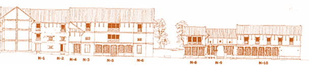
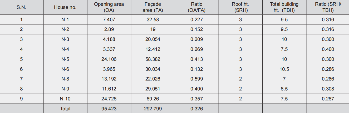
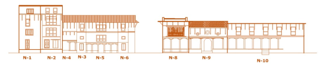
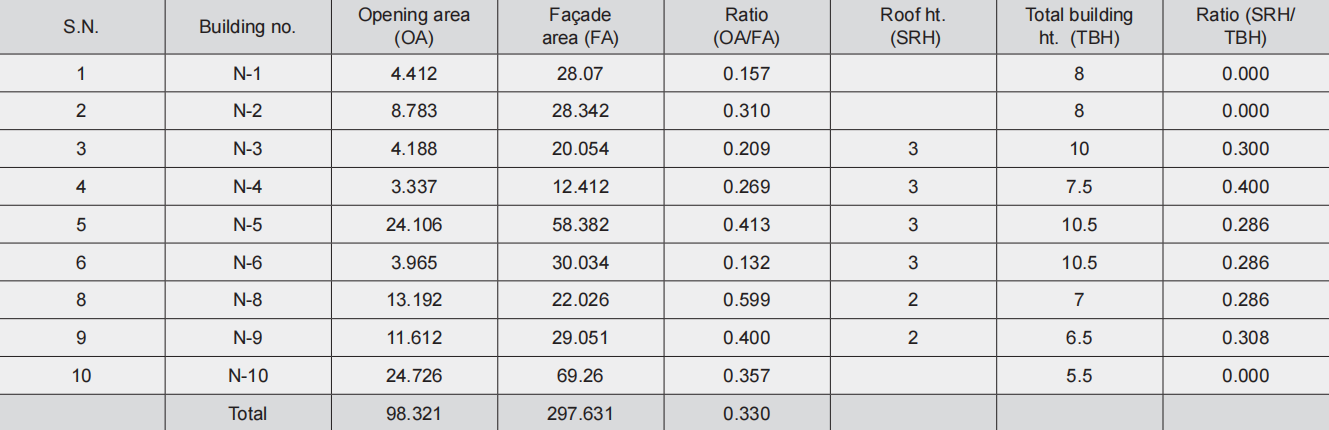
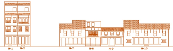
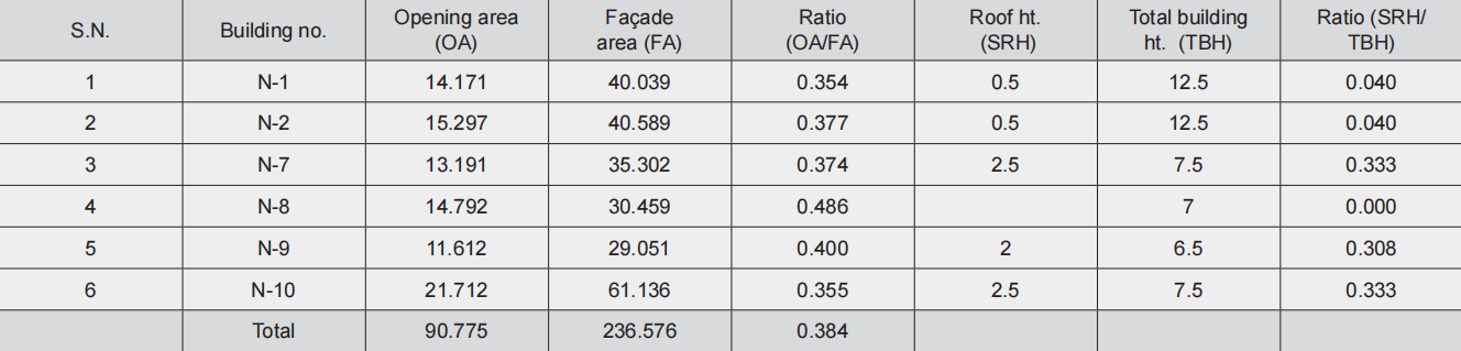
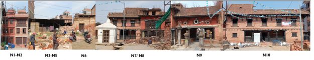
Table 2.1a Ratio of opening area to façade area and roof height to total building height (1968), 2.1b Ratio of opening area to façade area and roof height to total building height (before the 2015 earthquake), 2.1c Ratio of door and window opening area to façade area and roof height to total building height (as in 2024)
Houses on the south façade are mainly of residential use. The façade elevation in 1968 clearly demonstrates unique features of houses (Table 2.2a). The ratio of opening area to façade area (excluding roof area) ranges from 0.242 to 0.317 with an average value of 0.262. It means the openings (door and window) on façade area account for 24.2% to 31.7% of total façade area. Till that time, almost all houses had two-way sloped roofs. The ratio of roof height (seen in elevation) to the total building height ranges from 0.250 to 0.278. It means the roof height covers 25% to 27.8% of the total building height, which indicates the roof as a dominating element in building elevation.
By 2015, most of these traditional houses had been changed either through renovation or addition of floors on the existing houses (Table 2.2b). Some of them were also rebuilt from the foundation. As a result, the ratio of opening area to façade area increases, Interestingly, the newly built houses after the 2015 earthquake attempted to replicate some characteristics of the traditional houses, at least windows and some slope at least over the slab projection (Fig. 2.2c). The ratio of opening area to façade area lies in a range of 0.242 to 0.390. The opening size on façade of buildings ranging from 0.213 to 0.429. Renovated or newly built houses have flat roofs and some of them have a sloped ‘chatja’ over the window for protection from rain. The ratio of such slope to overall building height is around 0.167 only.
Interestingly, the newly built houses after the 2015 earthquake attempted to replicate some characteristics of the traditional houses, at least windows and some slope at least over the slab projection (Fig. 2.2c). The ratio of opening area to façade area lies in a range of 0.242 to 0.390. The opening size on façade of buildings ranges from 24.2% to 39.0% of total façade areas. The average value of this ratio is 0.338 in 2024 compared to 0.263 before the 2015 earthquake. Regarding the ratio of slope height to total building height, the value is negligible, meaning most of the houses have flat slabs with minor slope over window openings.
The east façade elevation also houses numerous residential buildings till 1968 (Table 2.3a). It has numerous unique features on houses as in other facades. The ratio of opening area to façade area comes between 0.219 and 0.415 with an average value of 0.298. Similarly, the ratio of sloped roof height to total building height is coming within the range of 0.222 to 0.278.
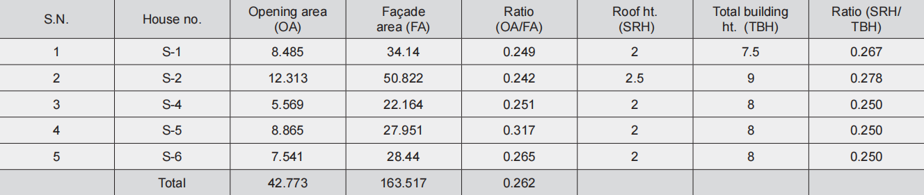

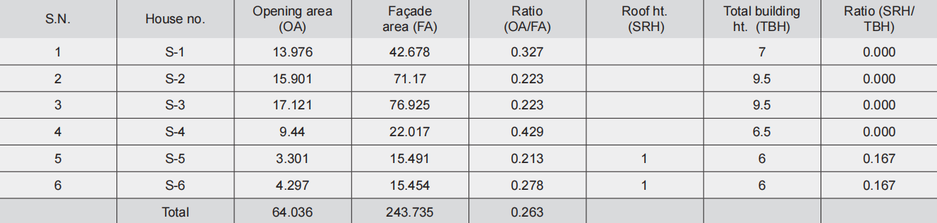
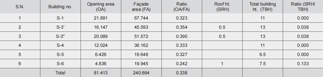
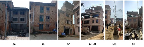
Table 2.2a Ratio of opening area to façade area and roof height to total building height (1968), 2.2b Ratio of opening area to façade area and roof height to total building height (before 2015), 2.2c Ratio of opening area to façade area and roof height to total building height (as in 2024)
Before the 2015 earthquake, many houses went under transformation, especially the addition of floors on the existing old houses and changing of door and window openings (Table 2.3b). They have also replaced the earlier sloped roofs with flat roofs (of CGI sheet or RCC slabs). The ratio of opening area to façade area comes in the range of 0.242 to 0.389 with an average value of 0.297, which is not much different from the value of 0.298 in 1968. However, another ratio of roof slope height to total building height has changed dramatically, because those renovated houses have replaced earlier sloped roofs by flat CGI or RCC slabs.
Though many houses are yet to be rebuilt, those newly constructed buildings have big windows and large openings on the ground, used for commercial purposes (Table 2.3c). The ratio of opening area to façade area lies between 0.289 and 0.394 with an average value of 0.344, which is slightly higher than the values of the previous two periods. As the newly built houses attempted to have some portion of slope especially over slab projection on the top floor, the ratio of sloped roof height to total building height is coming around 0.037 to 0.062.
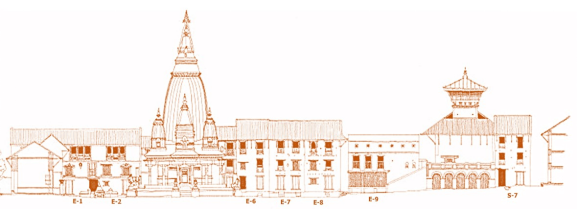
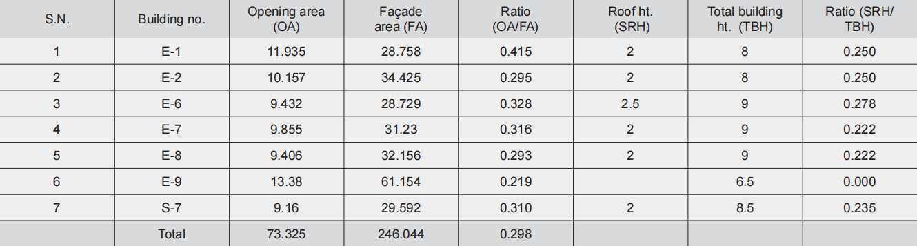
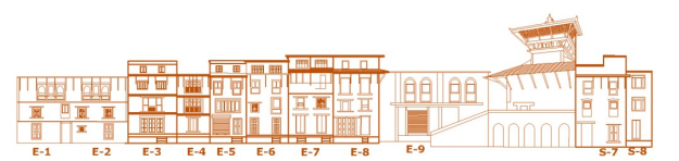
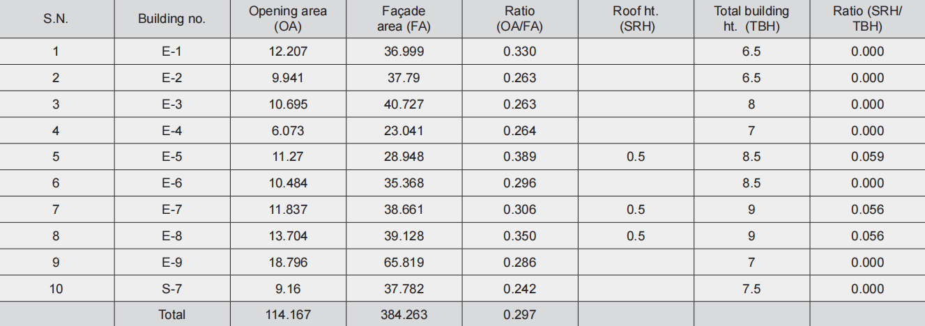
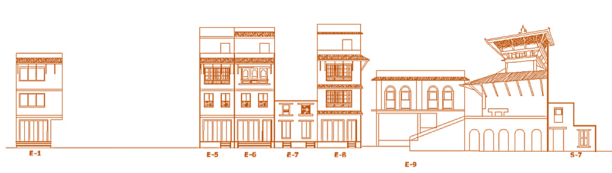
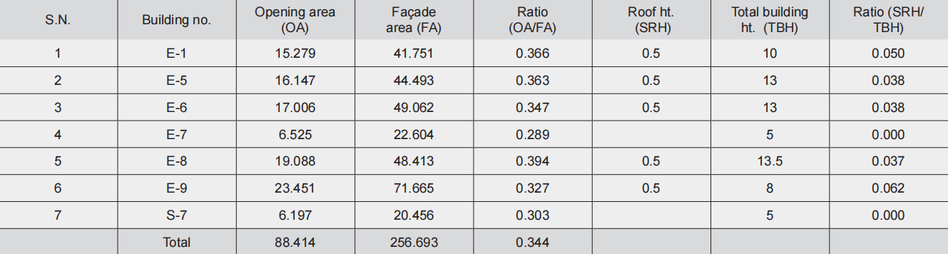
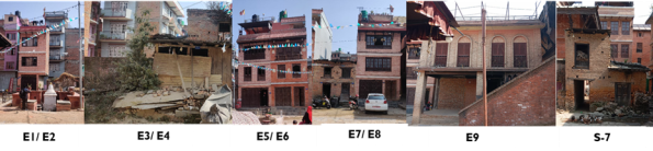
Table 2.3a Ratio of opening area to façade area and roof height to total building height (1968), 2.3b Ratio of opening area to façade area and roof height to total building height (before 2015), 2.3c Ratio of opening area to façade area and roof height to total building height (as in 2024)
The west elevation of building façade of Machchendra bahal also exhibits numerous unique features, which can be clearly seen in the elevation of 1968. Brick exposed plane façade with wooden doors and windows and dominant sloped roofs (Table 2.4a). The ratio of opening area to façade area (OA/FA) lies within the range of 0.188 to 0.395 with an average value of 0.286, which is similar to the values of other facades too for 1968. It means the opening of doors and windows on the façade of houses constitute around 18.8% to 39.5% of total façade area (excluding roof area). Similarly, the ratio of roof height (seen in elevation) to total building height lies in the range of 0.250 to 0.388. It demonstrates that 25.0% of the total building height is seen as sloped roof height, indicating the domination of the roof in the architectural style. This percentage goes up to 38.8% if the building is only two stories high.
These traditional houses have been modified especially with the addition of floors on the existing houses and replacing the earlier sloped roofs with flat CGS sheets (Table 2.4b). The ratio of opening area to façade area has not changed much from the 1968 case, as the values lie in the range of 0.188 to 0.355 with an average value of 0.285, which is similar to the value of 0.286 for the 1968 case. However, with the change on the upper floors, the façade has been After the earthquake, many houses were rebuilt from the foundation. Though those houses were built as per prevailing building byelaws, nonetheless, they have modified the qualitative and quantitative aspects of architecture of Bungamati (Table 2.4c). The ratio of opening area to façade area has increased, ranging from 0.257 to 0.533, with an average value of 0.339, which is much dramatically changed with the addition of windows on the top, which do not match the windows of the lower floors. As those modified houses have flat roofs, the ratio of sloped roof height to the total building height has come to be very insufficient. Only few houses have a small portion of slope over the window of the second floor (old houses).
After the earthquake, many houses were rebuilt from the foundation. Though those houses were built as per prevailing building byelaws, nonetheless, they have modified the qualitative and quantitative aspects of architecture of Bungamati (Table 2.4c). The ratio of opening area to façade area has increased, ranging from 0.257 to 0.533, with an average value of 0.339, which is much higher side compared to earlier values of 0.286 and 0.285 in 1968 and before the 2015 earthquake. As those new houses have attempted to include some slope over the projected slabs, the ratio of slope height (seen in elevation) and total building height slightly improved compared to the earlier before the 2015 elevation. However, this value is far less than the value of the 1968 elevation.
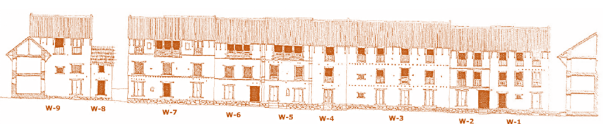
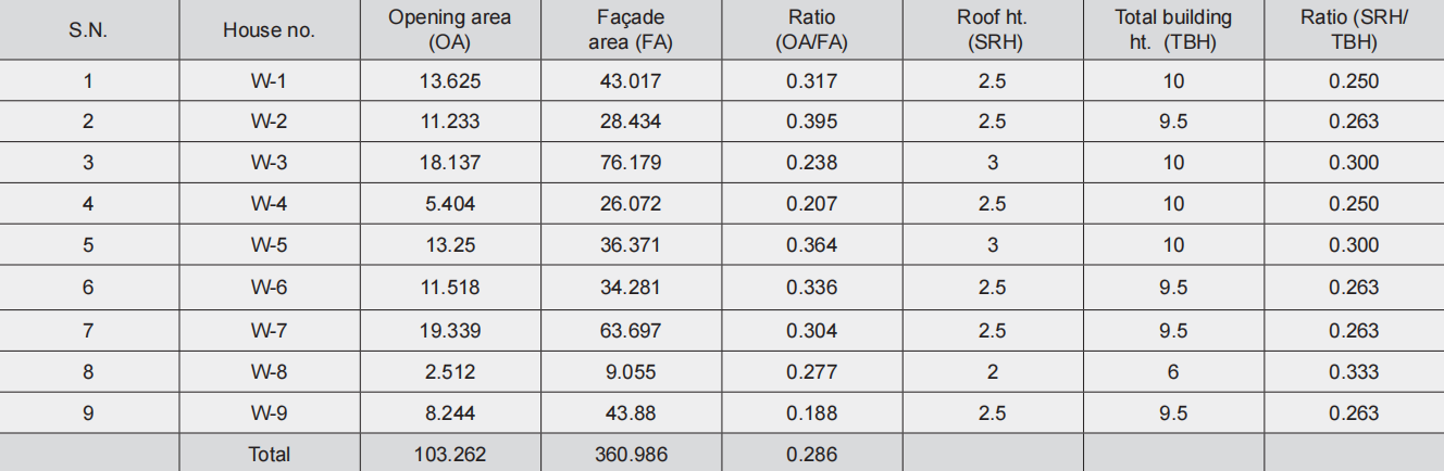
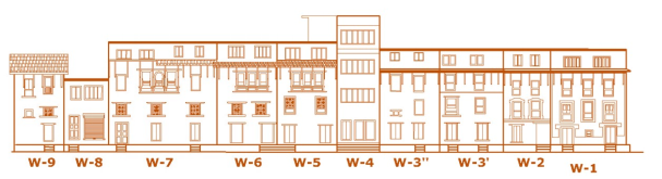
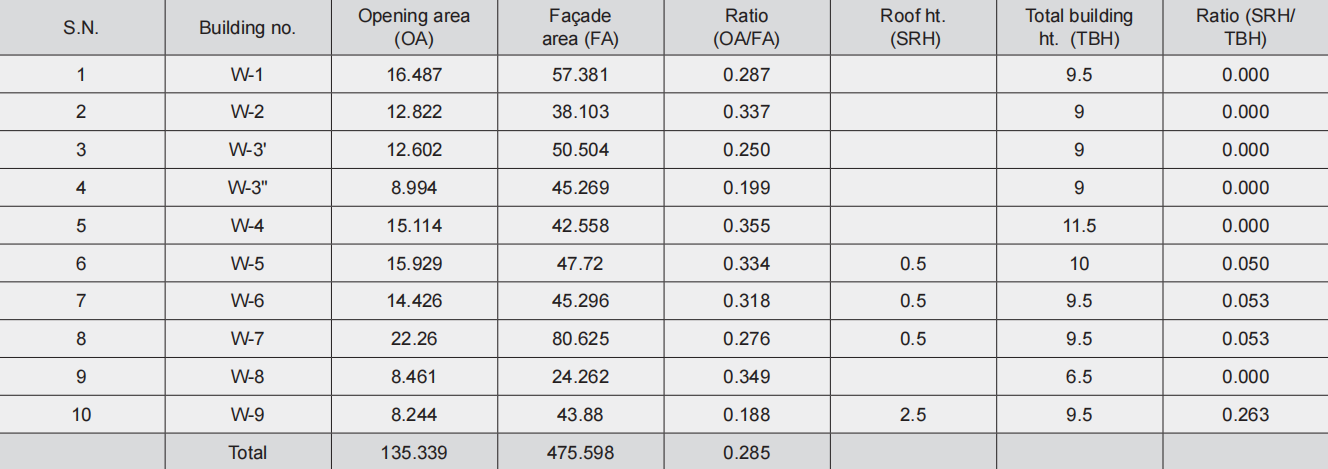
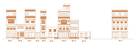
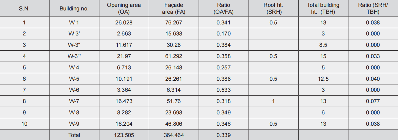
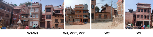
Table 2.4a Ratio of opening area to façade area and roof height to total building height (1968), 2.4b Ratio of opening area to façade area and roof height to total building height (before 2014), 2.4c Ratio of opening area to façade area and roof height to total building height (as in 2024)
Qualitative aspect of traditional houses and their transformation
1. Vertical façade with projection of balcony on the second floor only, door and window orientation and cornices
Like other Newar settlements in different locations, traditional houses in Bungamati have ‘plane’ building façade with projection of balcony in some cases on the second floor only (Figure 5). The flat surface of the façade is often of brick in mud or ‘surkhi’ mortar. The balcony is often of wooden projection and vertical railing. It is seen as light and transparent. The infill development and newly built houses after the 2015 earthquake hardly acknowledge features of traditional houses. Instead, they have destroyed the brick exposed vertical ‘plane’ façade by plastering and projecting balconies and parapet walls, besides making roofs flat.
Doors and windows used to be of wood and vertically oriented (Figure 6). They were not fully openable. In renovated houses and newly built buildings, windows are horizontally elongated. Instead of wooden panels, they have glass panels. Unlike the traditional wooden windows, they have a simple frame around the glass panel.
Changes can also be seen in the design and detailing of the cornices in old and new houses (Figure 7). Different types of cornice design in old houses do not dominate the building elevation. They are not prominent or distinct, as seen from far away. The newly built houses have a dominating horizontal band of cornices either of brick decoration or white painting over slab projection.
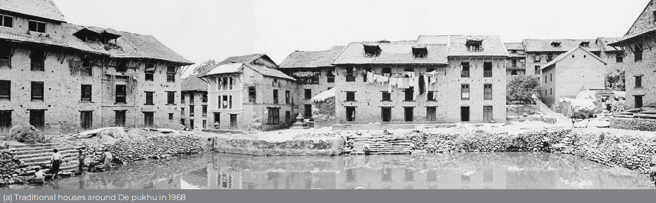
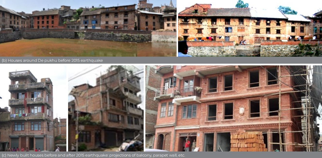
Fig 5 Transformation of brick exposed vertical plane façade to plastered and projected balcony
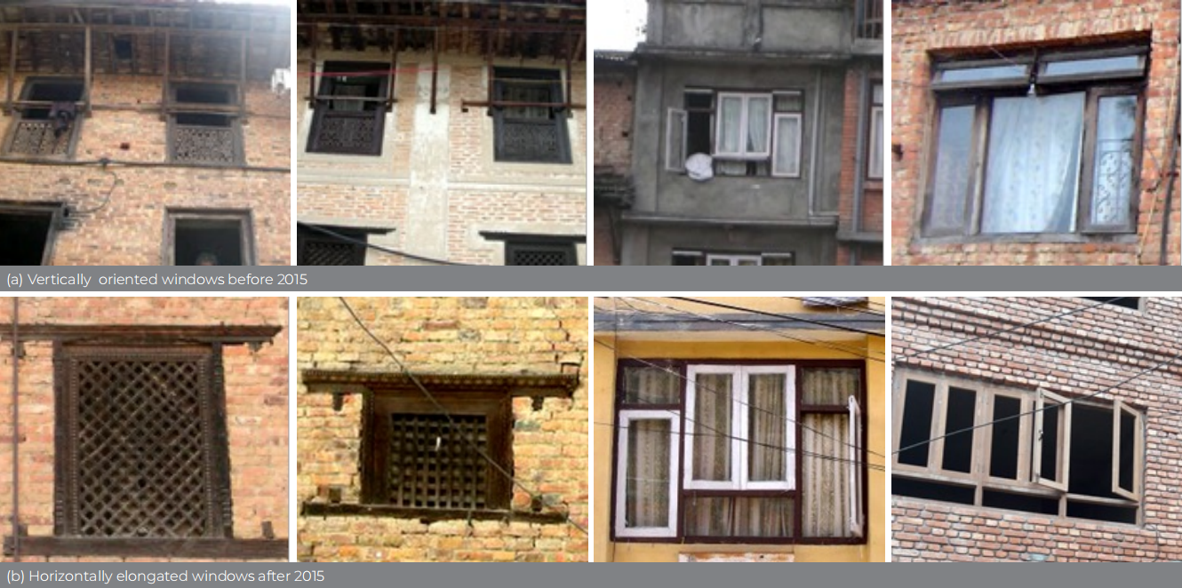
Fig 6 Changes in window openings on building façade
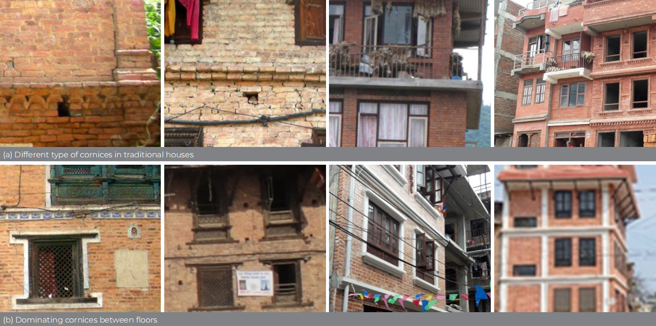
Fig 7 Changes in cornice design and detailing between old and new houses
2. Plinth as a transitional space between public and private domain
Plinth level in the old houses acts as a ‘transitional space’ between private and public domain. It is used as a socialization space, besides carrying out various activities (Figure 8). Such spaces are being replaced by continuous steps in newly built houses, which often have commercial use on the ground floor.
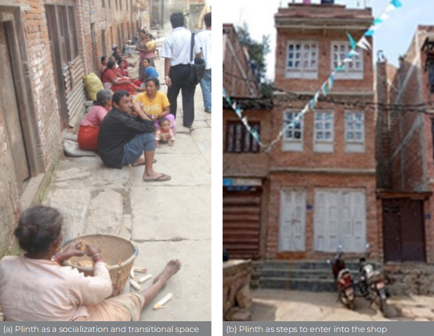
Fig 8 Destruction of plinth as socialization spaces
3. Dominating tiled roof supported by struts
Traditional houses in Bungamati have two-way tiled sloped roofs (Figure 9). They are the singular dominating element seen in elevation, covering around one fourth of the total building height. They have been gradually replaced by CGI sheets to prevent roof leakage. Tiles are also not easily available in the market. Newly built houses have flat roofs, in most cases with projection of slabs to increase the roof space.
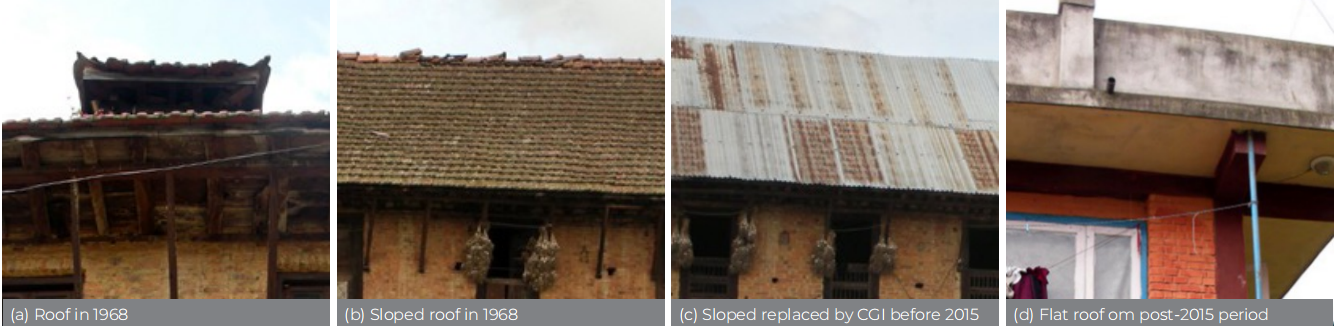
Fig 9 Changing style of roof: dominating element to disappearing unit in architectural style
Conclusions and key architectural design guidelines
Though Bungamati has numerous features of ’Newar’ towns in the urban areas, nonetheless, the built form has adjusted to high topography and local context. Moreover, there are some unique architectural characteristics that represent Bungamati. Critical quantitative analysis of the ratio of area of door and window openings to façade area and the ratio of sloped roof seen in elevation to total building height over three different periods (1968, before the 2015 earthquake and in 2024) reveals many facts. Almost in all facades, the openings (doors and windows) are less than 30% of the total façade area (residential buildings only), which increased slightly till the 2015 earthquake (Table 3). However, the newly built houses in the post-earthquake period have large size of openings on the building facades. In some buildings, the openings cover more than half of the façade area. Traditional houses in 1968 had around more than one fifth (20%) of the total building height as sloped roofs seen in elevation, which was slightly reduced till 2015. Most of the new RCC structures have flat roofs and, in some cases, a minor slope is put over window projection. Hence, it is suggested to have the ratio of openings to façade areas in the range of 0.20 to 0.35 and the ratio of sloped roof height to total building height between 0.10 and 0.25.
The following simple design guidelines on façade, door and window opening, cornices and plinth design including roof detailing are proposed (Table 4).
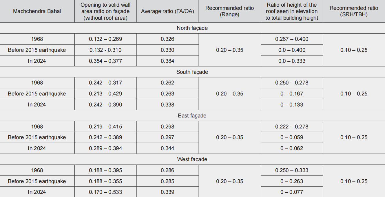
Table 3 Recommended ratios for the openings and roof in the building facades. Note: (a) Only residential buildings are considered in the calculation of the ratio of openings to façade. However, religious structure is also considered while calculating the ratio of total roof slope height to total building height; (b) FA = Façade area (without roof area), OA = door and window openings area on façade, SRH = Sloped roof height (seen in elevation), TBH = Total building height)
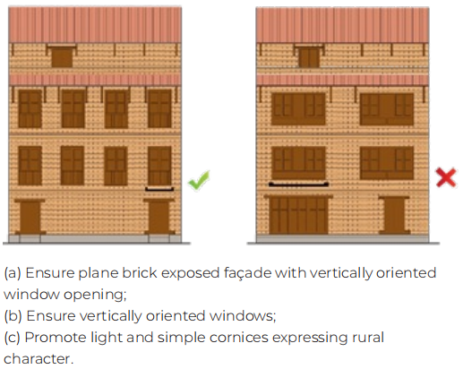
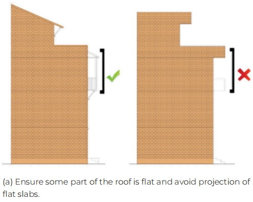
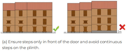
Table 4 Proposed key architectural design guidelines


 loading......